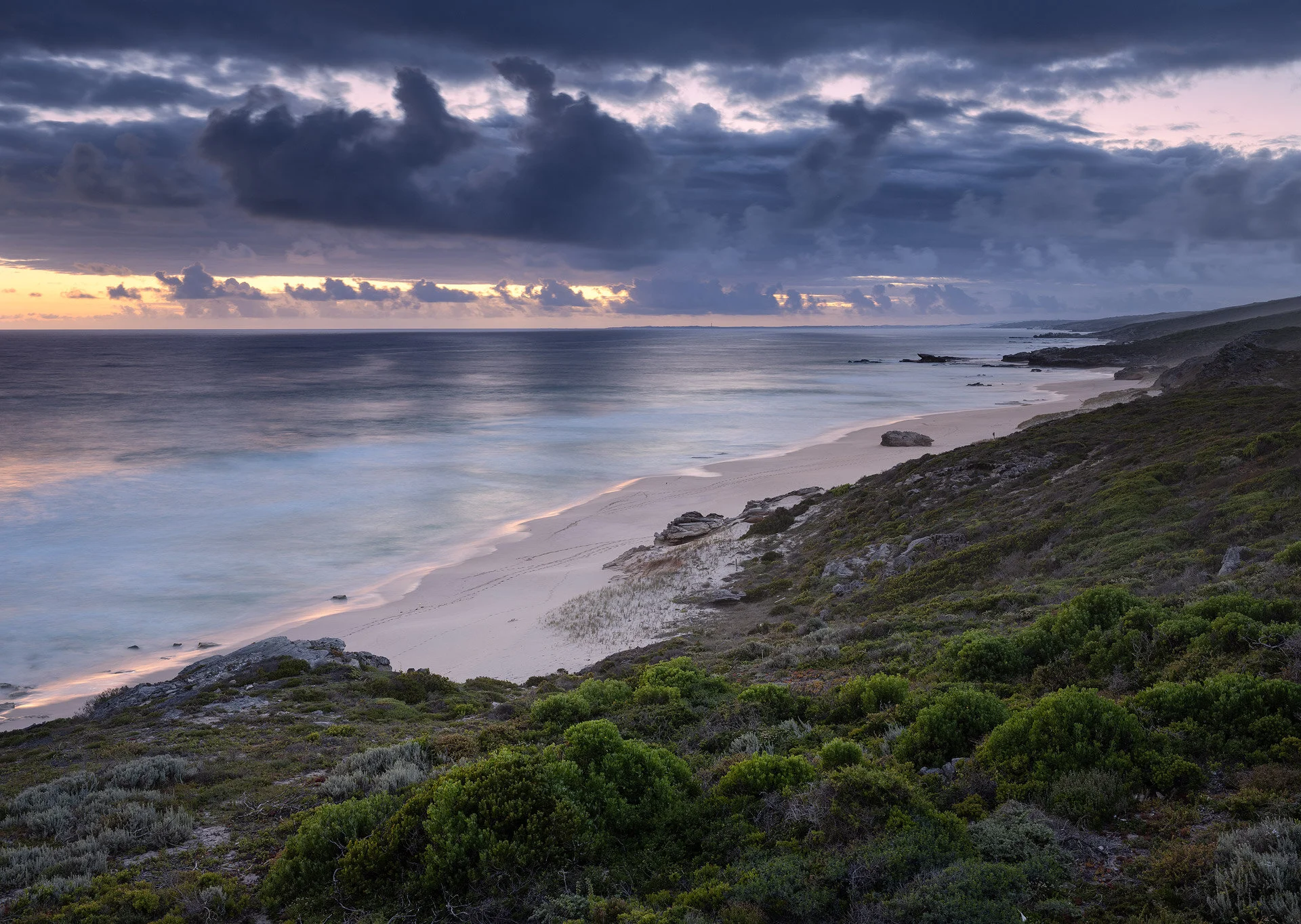
Late last year I was fortunate enough to spend a weekend with my family at a newly built lodge situated in a forgotten corner of De Hoop Nature Reserve. Lekkerwater, as the location is known, is where former president F.W de Klerk’s secret beach retreat was located and it is strikingly obvious why he chose the location. It is as untouched an area of the SA coastline as you can find with incredible natural rock pools and zero signs of civilisation. There were probably also fishing convictions involved as the name originally refers to the fishing potential of the area. A few years ago, the Natural Selection group landed the concession to take over the site and they worked their usual magic to create an intimate 7-bedroom lodge that makes the most of the seafront location.
”Lekker” is an Afrikaans word used to describe anything pleasant or enjoyable, so the name roughly translates to “pleasant waters”.

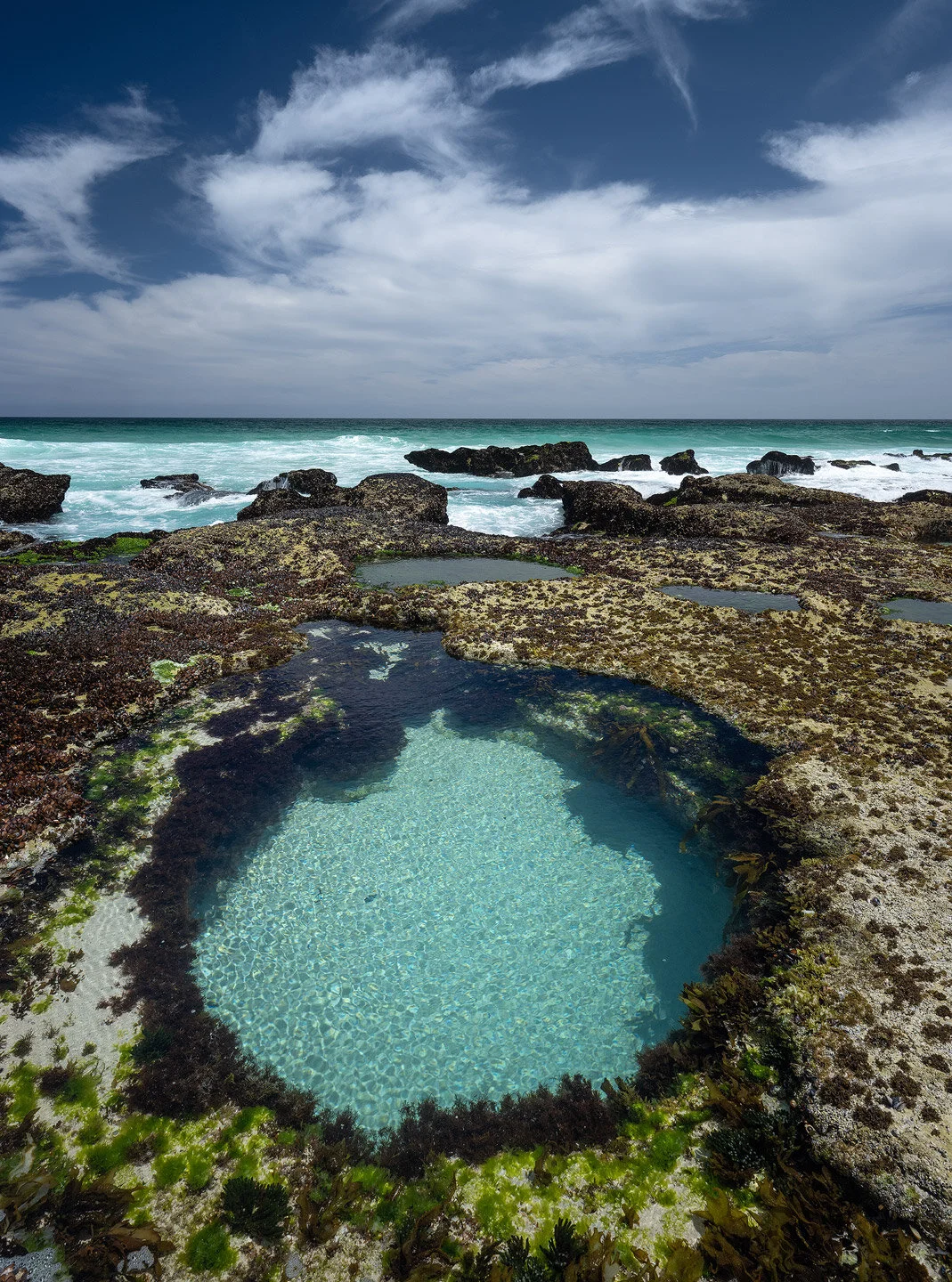
The resemblance to Arniston immediately excited me and over 3 days spent there, I fell deeply in love with the place. If you look out to Sea, you know that there is nothing but wild ocean, an uninhabited island or two and then the Antarctic. If you look East or West, there is nothing but untouched coastline in either direction. Free of people, free of footprints, free of roads and powerlines. This far Eastern corner of De Hoop NR is accessible only to visitors of the lodge or people hiking the Whale Trail. This lack of humans combined with the protection of being a marine reserve means that the coastline is in pristine condition – thriving dune vegetation, rock shelves covered in Mussels and Oysters, more Black Oyster Catchers than you can count and rock pools and waves teeming with fish. There are even tales of Cape Leopard on the beach and photos in the lodge to prove it. Seeing that we still have such a coastal sanctuary is incredibly heartwarming – it is a window into the coastline that once was, before we came along and pillaged everything.
Photographically, it is not as dramatic as the cliffs of Arniston, but the effect this pristine landscape has on visitors is unparalleled. At Lekkerwater I felt that I could clear my mind, breathe in the cool sea air and drink in the elements of the landscape like I haven’t been able to do anywhere else. I felt like I could slowly and carefully interpret nature and translate that into photos that tell the story of the ancient coastline at the southern tip of Africa. It is a location where I felt no obligation to wait for a red sky and get a striking composition, but rather to communicate the location honestly, regardless of light, colour or conditions. Of course composition and light play a role, but I felt at ease to deviate from the classic recipe for striking images and rather interpret the scene as presented. At Lekkerwater I found a specific combination of elements that I have been in search of for many years.

I have now spent over a decade teaching landscape photography to others and the great challenge with beginners has always been the technical side. Landscape photography is extremely technical and there are so many variables you have to deal with; camera settings, lenses, filters, weather, season, editing etc. It takes most people at least 5 years to get a good grip on all these technicalities, whether pro or novice. The unfortunate side of this is that most are so overwhelmed by the technical side, that they seldom get to the creative side of interpreting and communicating the subject. The photographic tours industry adds to this trouble as the whole interpretation process is circumvented through the copying of iconic compositions and locations. Photos are presented on a silver platter – copied and pasted, instead of created through conscious interpretation, pre-visualisation and careful composition.

While it can be very frustrating to rinse and repeat the same technical lessons to so many people, it has been incredibly rewarding to see so many of my students ascend the mountain of technicalities and break free of those constraints. Creativity and originality only begin when the technicalities have been programmed into your subconscious. It has been very fulfilling for me to walk a journey with so many people and get them past the technicalities. For several years now, I have wanted to create a new course that focuses on everything except the technicalities, but I’ve lacked the inspiration to do so. Within a day at Lekkerwater, I knew this was the place to do it. It resembles Arniston enough that I know it has fantastic potential, but it also differs enough that it offers many virgin opportunities. The inspiration of that untouched coastline, combined with the setting and ambience of the lodge is the perfect place to clear one’s mind and try to understand the convictions behind our love of photography.

I immediately phoned up my long time photographic tours partner, Shem Compion and shared the inspiration that I had stumbled upon. He spoke to the owners of Lekkerwater and we quickly figured out that the best months for seascape photography are coincidentally the worst months for beach-tourism. We came to an agreement and the result is that we can offer a 5-day workshop at Lekkerwater for close to the same price as a normal 5 day stay there.

The result is our first ever masterclass; a 4-night workshop in pristine nature and the lap of luxury. Over the last few years I have had many revelations in understanding my own creative process and I am very excited to share that with long time students. With every passing year I learn more and more that I have zero interest in photography and that the camera is merely an arbitrary tool with which I share my passion. Acknowledging things like these have opened my eyes to the creative process and what it is that I want to communicate when I take a photo.
This workshop will focus on understanding the psychology behind our own creativity, identifying our passion, interpreting nature, pre-visualising and capturing an experience in nature. Everything will be done with the final goal of printing the photo, hanging it in a home and ensuring that that photo communicates the original experience. My hope is that this incredible location can present all visitors with the introspective experience that it gave me; The ability to clear one’s mind of all distractions and get an objective view of the creative process over which we obsess so much. During this workshop, our aim will be to assist participants in achieving that objective view - to look past photography and it’s technicalities and identify the underlying passion for art and the natural world.
I love to hear other people’s opinions on this subject, so please comment below if you have had a similar experience at a destination.
The C4 Safaris office is handling all bookings. You can view the details on this link.
17-21 May | Only 2 rooms available
21-25 June | Only 1 room available
13-17 September | Bookings not open yet, please mail to be added to the waiting list
To those who have already booked a spot for this new venture, I cannot express my gratitude enough. Your support goes a long way in a year that tourism is on its knees.